Atlanta to Chattanooga I‑75 Corridor
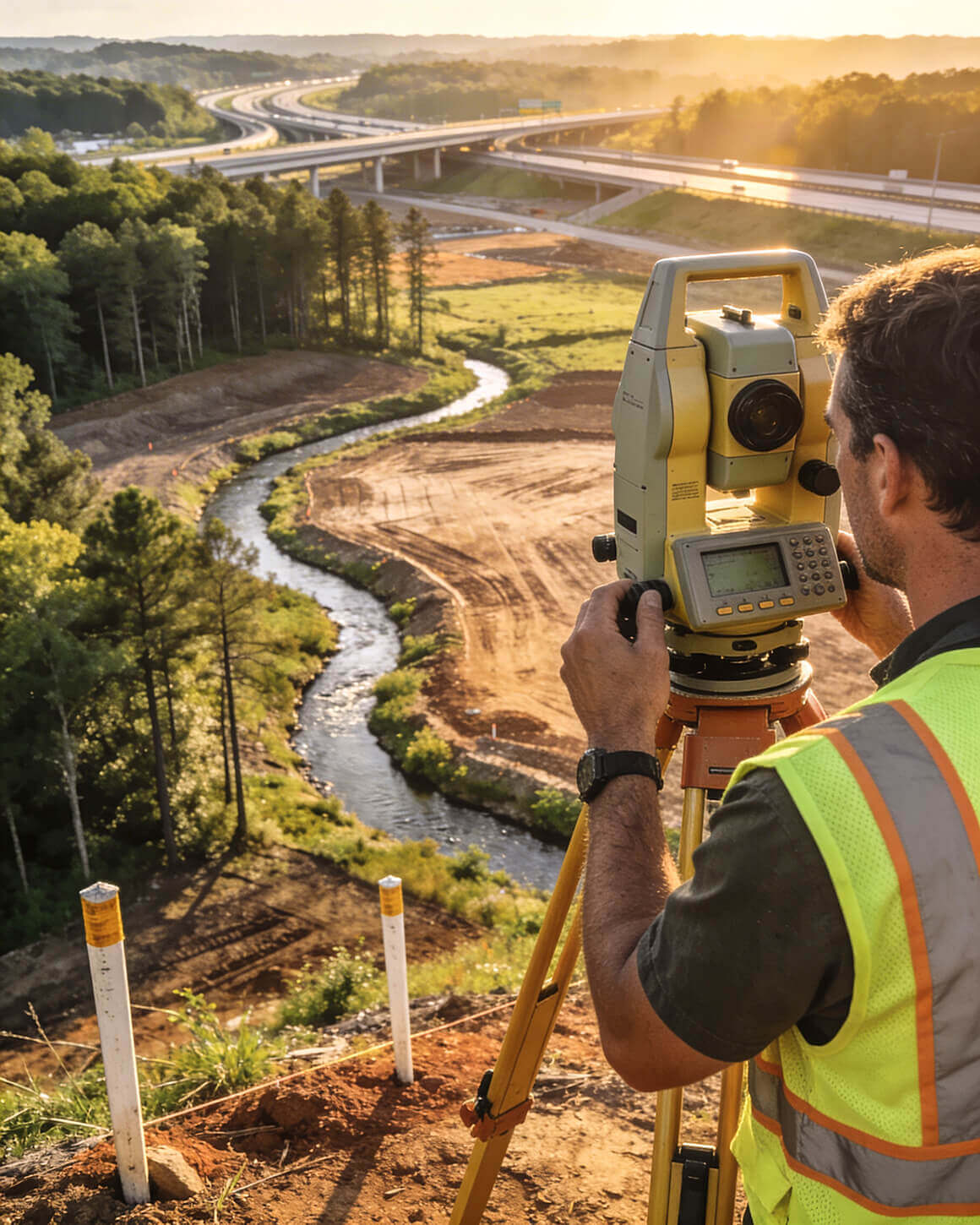
Aerial LiDAR Surveys

Ground crews can't keep pace
with corridor-scale projects.
LiDAR can.

For large properties, difficult terrain, and projects where data density matters, aerial LiDAR captures in hours what ground crews need weeks to collect.

The question isn't whether LiDAR is faster — it's whether you're using the right method before the schedule costs you money.

One firm. Four state licenses. Twenty years on this corridor — and the right method for your site.

Schedule Your LiDAR Discussion

15-Minute Call to Review Site Size, Terrain,
and Data Requirements.

Aerial LiDAR terrain scan — I-75 Corridor
1,200
Acres surveyed
By LiDAR — One day
5–10
Points per sq. meter
Standard resolution
4
State licenses
GA · TN · AL · KY
20+
Years in
the corridor

Using the Wrong Collection Method Has a Daily Cost

Every week of delayed terrain data is a week design can't advance. At $2,000–$5,000 per day in construction delays, the decision between ground crews and aerial LiDAR is a financial question before it's a technical one. Here's where that calculation goes wrong.

01
Ground Crews on Large Sites

Traditional ground surveys run 2–4 acres per day in reasonable conditions. A 200-acre industrial site takes months. A 500-acre logistics corridor is a quarter-year project. By the time topo data is complete, design timelines have already compressed.

02
Wooded Terrain Slows Everything

The I‑75 corridor is not open ground. Heavy canopy, steep hillsides, creek drainages, and dense undergrowth cut traditional field productivity by half or more. Sites that look manageable on a map take twice as long when crews are on the ground in North Georgia woods.

03
Compressed Design Timelines

Lenders and developers don't schedule projects around survey crews. Due diligence windows close. Permitting calendars don't flex. When terrain data arrives late, everything downstream stacks up — engineering, grading plans, permit applications, construction bids.

04
GIS Data Is Not Survey Data

GIS elevation data runs 6–10 feet off field reality in places across this corridor. Engineers who design from GIS-derived grades find out what the terrain actually is when contractors start moving dirt. That discovery is expensive. Field-verified LiDAR data closes that gap before design dollars are committed.

!

These are not edge cases. They are the standard operating conditions across the Atlanta to Chattanooga I‑75 Corridor. The question is whether they surface before the right method is selected — or after the schedule is already bleeding.

The Connector Real Estate Newsletter

Not ready for a call?

The Connector brings I‑75 Corridor development intel straight to your inbox — twice a month, no fluff.

    We Know What the Data Means

    Local knowledge doesn't just help in the field — it determines what LiDAR data means once you have it. The I‑75 corridor sits at the southern limit of the Appalachian Mountains, transitioning sharply into river basins. That transition creates terrain conditions that no out-of-state firm will recognize until they're already in trouble. We've been working this ground since 2004.

    Appalachian Transition Terrain

    Elevation changes of 50+ feet over short distances. Ridge lines, creek valleys, steep wooded hillsides — ground crews need weeks. LiDAR needs a day. We know which sites will push the limits of traditional collection before boots ever hit the ground.

    Old Farm Terraces and Hidden Drainage

    1900s-era terracing runs across properties that look flat on paper. Ditches, swales, and hidden drainage features built over a century of use. LiDAR captures every one. GIS misses most. Our team knows where to look and what it means for your grading design.

    1,200-Acre Farm Conversion — One Day

    Traditional methods: 2–4 acres per day. The whole site would have taken months. LiDAR: entire 1,200 acres in one day, delivered before ground crews would have finished the first corner. The project moved directly into design without a delay cycle.

    Surveyor on I‑75 corridor site
    20+ Years in Corridor
    4 State Licenses
    5–10 Pts / Sq M
    Standard

    What You Actually Get From an Aerial LiDAR Survey

    LiDAR collects millions of elevation points across your site — classified by type, georeferenced, and delivered in the formats your design team loads directly. This is what that means in practice.

    Point Cloud Data

    Millions of elevation points versus thousands from a ground survey. Dense, classified data covering every part of the site — not interpolated estimates between field shots. Engineers and civil designers work from this directly.

    Canopy Penetration

    LiDAR pulses return from multiple surfaces — treetops, mid-canopy, and ground level. The bare-earth model under heavy tree cover is something ground crews can't replicate efficiently on heavily wooded I‑75 corridor sites.

    Classified Layers

    Bare earth, vegetation, structures, utilities — each separated into its own data layer. Architects site buildings on bare earth. Engineers route utilities around structures. The data works for each discipline without re-processing.

    3-Inch Aerial Imagery

    3-inch pixel resolution aerial imagery layered over elevation data. Your team sees the site, not an abstraction. Useful for site planning, presentations, stakeholder approvals, and identifying conditions that don't show in elevation data alone.

    CAD-Ready Deliverables

    Contour lines at specified intervals, spot elevations, surface models, and classified point clouds — in AutoCAD, Civil 3D, and other standard formats your engineers use without conversion steps or re-work.

    Survey-Grade Accuracy

    We set ground control points and certify survey-grade accuracy. This isn't approximation data. It's stamped survey data collected from the air, accurate enough for permitting, construction documents, and lender review.

    !

    On a 28-acre commercial site in the corridor, we combined 250 ground elevation shots with LiDAR and merged the surfaces. Flat areas that looked buildable were floodplain. It changed the entire buildable area calculation before design began — not after construction revealed the problem.

    The Process That Protects Your Timeline

    We approach LiDAR as a scoping conversation before it's a field operation. Not every project needs aerial collection — and we'll tell you honestly if yours doesn't. When it does, here's how we structure the engagement.

    01
    Site Evaluation

    Does LiDAR make sense for this project? We evaluate acreage, terrain complexity, timeline, and deliverables required. If ground collection is the right tool, we'll say so. Method selection is the job — we don't sell LiDAR when it doesn't fit.

    Protects → Budget and method fit
    02
    Resolution Spec

    5–10 points per square meter is our standard corridor collection. Higher density is available for precision applications — athletic fields, ADA surfaces, floodplain modeling. We set resolution based on what the deliverable actually requires.

    Protects → Data precision
    03
    Ground Control

    We establish ground control points across the site before flight. This is how aerial data achieves survey-grade accuracy — not approximation, not interpolation. The data is stamped and certifiable because the control is real and verifiable.

    Protects → Accuracy and certifiability
    04
    Deliverables Package

    Point cloud, classified layers, contours, aerial imagery, and surface models — in AutoCAD, Civil 3D, or the format your team loads directly. One data collection. Every format your engineers and architects need.

    Protects → Design timeline

    Knowing Which Tool to Use Is Part of the Job

    LiDAR wins on large acreage, difficult terrain, and speed. Ground surveys win on precision grading, small sites, and combined topo/boundary work. Most large development projects need both. Here's how to think about it.

    Project Condition Aerial LiDAR Ground Survey Combined Approach
    50+ Acres Best fit — hours, not weeks Slow — months on large sites LiDAR full site, ground spot-check
    Under 20 Acres Overkill — mobilization cost doesn't pencil Best fit — faster, less expensive Rarely needed at this scale
    Heavy Tree Canopy Advantage — penetrates to bare earth Slows significantly LiDAR for terrain, ground for boundaries
    Precision Grading Adequate — ground is more precise Best fit — tighter tolerances LiDAR the site, ground survey the build pad
    Topo + Boundary Boundary still needs ground Handles both in one mobilization Standard for most corridor projects
    Large Infrastructure Best fit — corridor-scale efficiency Cost-prohibitive at this scale LiDAR full corridor, ground at design nodes
    $150,000
    Per Month. Currently.

    We are currently watching a developer spend $150,000 per month because grading was designed from bad survey data. The grading contractor is manually balancing dirt across a site that was engineered incorrectly from the start. That project has been running for over a year.

    It started upstream — with a method decision made before design began. The data was inadequate. The design was wrong. By the time construction revealed the problem, there was no inexpensive fix. The terrain assumptions that could have been resolved before design began compounded into a nine-figure problem.

    LiDAR doesn't guarantee the project goes smoothly. But it removes terrain assumptions from the list of things that can go wrong. The cost of skipping the right method — or using a firm that doesn't know the terrain — shows up later, when the meter is running and the options are expensive.

    Large-Site Ground Survey

    At 2–4 acres per day, a 200-acre industrial site takes months. If LiDAR was the right call and ground crews are used instead, the delay compounds across engineering, permitting, and construction bid schedules.

    Wrong Method on Wooded Terrain

    Dense canopy and steep terrain reduce traditional field productivity by half or more on this corridor. A site that looks manageable on the desktop takes twice as long when crews are on the ground in North Georgia woods.

    GIS Data Treated as Survey Data

    GIS elevation data runs 6–10 feet off field reality across the corridor. Engineers designing from GIS-derived grades discover the actual terrain when contractors start moving dirt — after design dollars are committed.

    Method Decision Made Too Late

    LiDAR for a small site means mobilization costs that don't pencil. Ground crews for 500 acres means a quarter-year project. Method selection is a pre-design conversation. When it happens after mobilization, the schedule and budget absorb the correction.

    Your project has a timeline.
    Ground crews have limits.

    Let's talk about what LiDAR can and can't do for your site before you commit to a method that costs you weeks. If ground collection is the right call, we'll tell you. If LiDAR is the right call, we'll scope it and deliver data your team can build from.

    15-minute call to review site size, terrain,
    and data requirements.

    1 Day Large-Site Collection
    GA · TN · AL · KY Licensed States
    Since 2004 Corridor Experience